Showing posts with label backpacking. Show all posts

14 December 2010

New Publication in Backpacking Light Magazine

News of the Day:

Kristin and I are very excited to announce our second publication in Backpacking Light Magazine. It is such an honor for us. The article, Valley Hopping in the Cordillera Huayhuash, details an arduous seven-day high-altitude trek in Northern Peru that we accomplished in May 2010. We have several articles in the pipeline to be published by Backpacking Light Magazine this year. If you want to read our articles, you will save money with the year subscription, over the pay-per-article basis.

On other news, I'll continue publishing the Year In Review Daily Photo, as well as back-blogging from our last adventures in Russia (Siberian Cities, Altai Mountains, Moscow), Istanbul, and about our current break in Bulgaria. 

Lastly, it is snowing today and it feels like Christmas!! Next Monday, we are renting a car for 2-3 weeks to drive around Romania, Bulgaria and Greece. Our friend Beth, from the States, is joining us for this road trip. 

We're still hanging out in the empty, remote village of Kosharitsa in Bulgaria. We are 7km from the Black Sea, and near the UNESCO World Heritage City of Nesebar. Keep checking back with me for more stories and photos of our three months in Bulgaria. 

17 May 2010

Alive and Well

Kristin and I are back in Huaraz after seven days of backpacking the Huayhuash Loop, which many say is one of the best treks in the world. Well, we certainly took enough pictures that give some credit to that claim. I cannot say I've hiked enough to be able to rank treks on a global scale. However, we camped above 4400 meters (14,400 feet) every night and hiked over numerous 5000 meter (16,500 feet) passes. We saw several locals, only two other backpacking groups (with guides) and zero independent hikers in our week on the trail. As I can edit and upload photos, I'll start sharing our tale.

As for me and Kristin, we are enjoying our last day in Huaraz. We have been staying with our gracious friend, Gary, and his family. Tonight we take an overnight bus to Lima. We will spend half a day there, buying food, checking out the Miraflores District, and trying not to get shot. Then we have a lovely 22-hour bus ride to Cusco. Luckily, I have plenty of photos to edit, emails to catch-up on, and books to read.

My mom and her friend are meeting us in Cusco, which is the nearest city to Machu Pichu. After a week of exploring Incan ruins, Kristin and I will continue south to Arequipe, where we'll trek through the Colca Canyon. Then it's off to Lake Titicaca, across the Bolivian border, a week in La Paz with Brady, south through the Andes to the great salt flats (Salar de Uyuni), into Chile via San Pedro de Atacama, and finally arriving at Santiago towards the end of June.

Our itinerary for the next five weeks is actually planned because we have a flight from Santiago to San Francisco on June 23. That's right, we are flying home! We are very excited to see local friends and family. However, we will not stay long as we want to head west, over the Pacific, to wherever the wind takes us. Email me if you'll be around. Hope to see you soon!

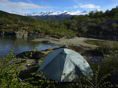
Until the Huayhuash travel posts are ready, here is a little eye candy to tide you over:


More stunning sceneries with glacial lakes and dramatic peaks.

More bad weather.

And more macro shots.

Also, on the right side of this blog are the Stats Page, which is current as of today, and the TarpTent Love Page, which shows our camp spots over the last eight months and is updated as of the Santa Cruz Loop.

15 January 2010

Cochamó - Thorougly Soaked

Last week we had the brilliant idea to hike from Chile through the Andes to Argentina. Dire warnings about "bad weather" weren't going to stop us. We're in Patagonia after all. In ways, the weather defines the experience. But sometimes, the only way to enjoy the experience is to ignore the weather and to keep on trekking. It is said that only tourists talk of the weather here.


Well, that was before this summer. While Cochamó Valley saw the sun about half of the days last summer, we were in a spell of at least 26 rainy days out of 31, according to local climbers. It has been the rainiest season in history. Who knows how far back local history (read: memory) dates? Regardless, it was bad. On most days the clouds impeded the views of soaring granite cliffs and precipitous waterfalls. However, in the rare moments of spacial clarity, we were stunned with what we saw: a Yosemite virtually unbeknown to North America. There are no roads here. There are three buildings: one is an extremely basic hut used by campers for cooking, one is a caretaker's house, and one is a simple, rustic refugio where you can stay in a bunk for the night. During the summer the valley is temporarily populated by hopeful climbers and a few curious backpackers. Trails are muddy and steep, the routes are heavily vegetated, the weather is foul, and even the hike into the valley is difficult. However, at the end of this arduous trail of climbers love and perseverance is the chance to put up a new route on a big wall. Where else in the world can a climber do that?

I did notice a high proportion of climbers from Boulder Colorado. I also heard a few comments of "it's the Yosemite of South America" or "it's like Yosemite without all the tourists." While this are both true, there is already a Yosemite, and it's in California. I didn't find any other Californians wondering the globe for another Yosemite.

Kristin and I thoroughly enjoyed the hike, even if we didn't fully embrace the rain. At the end of the week, we made it Argentina. Mold was growing on certain textiles, but we were able to keep dry our precious things: books, computer, and sleeping bag. Yes, we were able to hike with 7+ days worth of food plus everything we need for the rest of South America.


Big Walls


Big Trees


Deep Muddy Trails


I'll write more about the Valley (as will Kristin), post more pics, and tell two more tales of border crossings (yes, two more!). But now, you must let me enjoy some hard-earned Argentinean sunshine and chocolate. Ciao!


23 December 2009

Video from Hiking in Los Glaciares

A quick video from our trip to Fitz Roy in Los Glaciares National Park Argentina. Taken about 3 weeks ago.

19 December 2009

Torres del Paine


With Torres del Paine, we concluded our tour of southern Patagonia and its triumvirate of stunning parks - Tierra del Fuego, Los Glaciares (Fitz Roy), and Torres del Paine. We spent the last month criss-crossing borders in search of the best backpacking. We found it in Torres del Paine (TdP), along with thousands of other people and high costs.

04 December 2009

Yo, Robot.

Since arriving in South America, I have seen more Will Smith movies than I had in my entire life. I don't know what this says about me.

Regardless, it is hard to escape American culture, whether it is Friends or Sex and the City with subtitles, or an American idea turned into something like Latin American Idol or the numerous reality shows. The top three bands I've heard? Beatles, Bob Marley and Queen. Yes, technically not American bands, but you get the point. English is the de facto international language, and American pop culture is becoming the world's culture. Now if we could just do something about the sliding value of US dollar, that'd be great.

Food, transportation and sleeping arrangements are the three constant challenges of our journey. Kristin blogged about the food situation already. I'd just like to echo her sentiment that it is very difficult to pay for food you don't really like. It's worse when you have to pay too much for it. It's particularly hard to plan a 8-day camping trip when your choices are thus limited. I mean, I haven't had peanut butter since Guatemala. I don't know what to do for lunch!

We are really lucky, particularly in Northern California, that we have such a wide selection of good foods. Not that everybody takes advantage of that, but I know I couldn't live without it.

On that note, we're heading into the "wilderness" of Torres del Paine. This is a park that I've dreamed of visiting. Like the rest of Patagonia, it is absolutely notorious for unpredictable, rapidly changing weather and ferocious winds. We'll see how our little TarpTent does! And 8 days of processed food should be exciting.

Note: we will be out of communication for the next 8-10 days. If the world ends during that time, we'll have to wait until we get back to check Google News to find out. Until then, here are a few pictures from our last hike in Los Glaciares National Park, Argentina. Ciao!

Wind and snow are all part of the daily fun.

Even though it looks like Spring, we're certain to get all four seasons in one day. True Patagonia weather.

Glaciar lakes, tumbling waterfalls and towering peaks - it's worth the effort!

30 November 2009

Los Glaciares

Sure, it´s easy to exagerate when things are good, but I´m careful when I talk about parks. I´m not exagerating when I say that Los Glaciares is the most dramatic park I have ever been too.
Located in southern Patagonia, this park is Argentina´s response to Chile´s Torres del Paine. Los Glaciares protects South America´s Continental Ice Field. It is the largest ice mass outside of Antarctica and Greenland. It is home to a silly number of glaciares and many of them are approachable within a day´s hike from town. However, why would we pay to stay in a hostel when we can camp for free in the park?

29 November 2009

Tierra del Fuego

This "Land of Fire" is anything but fiery. It was cold, rainy, snowy and windy. But it was also well worth heading to one of the southern-most national parks in the world to get in some great hiking and camping.

The entire southern region of Argentina & Chile is called Tierra del Fuego because British explorers noticed that along the shores and many islands were fires, started by the natives. The name stuck but the warming fires did not.

Our taxi/bus driver stopped on the way up to the park entrance, wasting a few minutes but saving us 50 pesos each (about $25 total). We were entering the park after hours and wouldn´t have to pay the entrance fee. Yay! Furthermore, the camping was free. Doublegood. We knew this cheap camping wouldn´t happen everywhere. The more popular parks are quite expensive, costing $20-40 US per person just for the entrance fee.

The first night we hiked south, to a lookout viewing the Beagle passage. We were the only ones there. The next day we hiked up a nearby mountain peak. The last two hours up were in snow, but we had no trouble with just our sneakers and light gear. At the top we were afforded excellent views of mountains all around.

It started snowing on our way down. Mind you, a few days ago we were in the semi-arid desert of Santiago. A few days before that we were in the tropical forests of Costa Rica. How the times have changed - now we´re enjoying spring skiing conditions! If only we had our skis . . .

We also hiked along one lake all the way back to Chile. For some reason it´s illegal to cross borders by yourself. There is nothing at the border but more forest, so of course we explored a little further. Shhh, don´t tell the Chilean border patrol.

On the third day in the park we hiked to a nice flat area. The trails were fairly muddy as it had been raining most of the night, so this day was unspectacular except for a few fine views. In three days we had hiked almost all of the trails and so it was time to move on again. Now we´re heading to our most ´northern´section of southern Patagonia ' Los Glaciares National Park.

Yes, this really is the end of the road . . . a road that started 17,848 kilometers earlier in Alaska. Some people travel the length of this by motorcycle or even bike. We are happy to just be here.

The view from our campsite on the first night. We had the place to ourselves.

On our way to the top, before it started raining and I donned even warmer clothing. Far behind me is Chile.

[Note: This blog was written for the time period of Nov. 19-21]

26 October 2009

Corcovado National Park

A few people have mentioned this park, on the far southern Pacific tip of Costa Rica. C.G. in particular called this the "best park in Central America." That's a pretty strong statement, but it was coming from someone who spent a lot of time down here and knows what he's talking about, someone I could trust.

So, we took another long bus ride from San Jose down to a one-street town called Puerto Jiminez, which is our jumping off point into the park. It's another 2 hour truck ride from here, which only got us 32 km closer to the park. We then had to walk because the truck couldn't cross the swollen river (seven straight days of rain). We walked 10km to the beach, where we set up camp. The next day started with another 3.5 km along the beach to the park entrance. However, all this effort was well worth it as we saw more wildlife in one day than we have anywhere else (so far). It is the off season, so we nearly had this side of the park to ourselves. It was hard to take in all of the animals - too many to count. So, here's a few pictures. Will post more later, along with more details of what we're up to. Tomorrow we're heading back into the park, but via another entrance: Rio Tigre. This is more mountainous, less visited, and even rainier (is that possible)? Until then, a few photos to keep you wondering . . .


Hiking through the jungle, all to ourselves.


Making a new friend


Tons of hermit crabs. If only you could eat them . . .


Too much tree to hug!


Spider monkeys, eating and playing, just like us.


An interesting new shelter that has made me reevaluate the necessity of a tent.

08 October 2009

Photos from Mayan Ruins

Our time in Northern Guatemala was well spent, but I ended up with salmonella poisoning which caused typhoid fever. I never had time to post the photos, so here I go:

Tikal - 900 AD

Climbing the stairs . . .

. . . to get views like this.

The most famous of Tikal's pyramids.

Giant trees and lots of wildlife really made Tikal a pleasant park. Overall, it was a perfect blend of rebuilt buildings, while not being too refined or commercial (like Chitzen Itza, Mexico).

Mirador - 2000 BC

It took a lot of imagination to see this place as the peak of Mayan civilization and the largest pyramid ever built.

Impeccably-preserved frescoes lined the irrigation canals. Really, who had the power to make gutters look this good?

60km from the farthest village and we still got cell phone connection. Gotta love flat states. Nothing but flat, humid jungle as far as we could see.